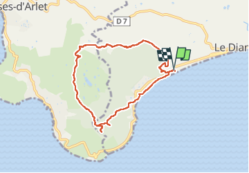
![](/images/other/stat-length.png)
![Tour Wandern Le Diamant - Lever de soleil au Morne Larcher - Photo](https://media.geolcdn.com/t/1900/400/ext.pjpeg?maxdim=2&url=https%3A%2F%2Fstatic1.geolcdn.com%2Fsiteimages%2Fupload%2Ffiles%2F1553511878bg_sport_marche.png)
Lever de soleil au Morne Larcher
ThereseH
Benutzer
![Länge](/images/other/stat-length.png)
![Maximale Höhe](https://static1.geolcdn.com/siteimages/upload/files/1508320355ic_sort_altitude_max_24dp.png)
![Positive Höhendifferenz](https://static1.geolcdn.com/siteimages/upload/files/1508320355ic_sort_den_pos_24dp.png)
![Km-Effort](/images/other/stat-length.png)
![Min. Höhe](https://static1.geolcdn.com/siteimages/upload/files/1508320355ic_sort_altitude_min_24dp.png)
![Negative Höhendifferenz](https://static1.geolcdn.com/siteimages/upload/files/1508320355ic_sort_den_neg_24dp.png)
![Boucle](https://static1.geolcdn.com/siteimages/upload/files/16400158638029165_repeat_loop_refresh_sync_direction_icon.png)
![Wandern](https://static1.geolcdn.com/sitytour/trail-icons/101.png)
5h06
Schwierigkeit : Sehr schwierig
![Scannen Sie diesen QR-Code, um die Tour in der SityTrail-Anwendung zu öffnen](https://capi.geolives.com/qq0zvz2zws4bq2lad0pu/sitytour/trails/3229299/qr.png?size=200)
Kostenlosegpshiking-Anwendung
Über SityTrail
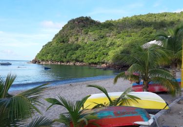
Tour Wandern von 11,2 km verfügbar auf Martinique, Unbekannt, Le Diamant. Diese Tour wird von ThereseH vorgeschlagen.
Beschreibung
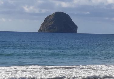
Rocher du Diamant ( Neck, réserve naturelle ....)
Morne Larcher 478 m - Panorama à 402 m
Roche Andésite
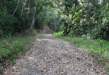
Ancienne Carrière visible à Montfleuri
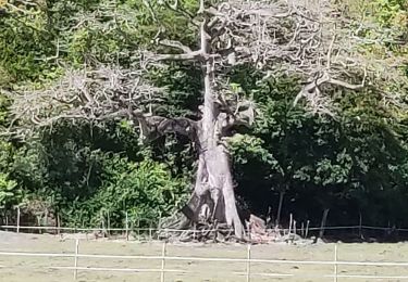
Prairie avec mare aménagement agricole élevage bovin
Haras et elevage bovin de bramahne
Station épuration pionnière.
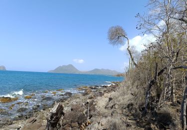
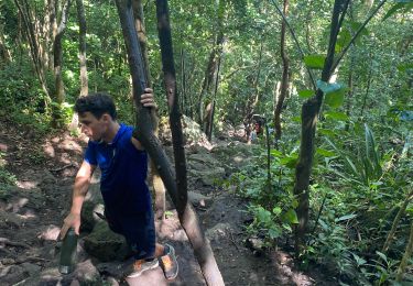
Forêt xérophile. Chaleur et déssèchement
Ort
Kommentare
Touren in der Umgebung
![Tour Wandern Le Diamant - le Diamant de Taupinière vers O'mulane bas. - Photo](https://media.geolcdn.com/t/375/260/653f0fe3-b889-4758-982c-8d8f505a6e15.jpg&format=jpg&maxdim=2)
![Wandern Wandern](https://static1.geolcdn.com/sitytour/trail-icons/101.png)
Wandern
![](/images/other/stat-length.png)
![](https://static1.geolcdn.com/siteimages/upload/files/16400158638029165_repeat_loop_refresh_sync_direction_icon.png)
![Tour Wandern Les Anses-d'Arlet - Morne Champagne - Photo](https://media.geolcdn.com/t/375/260/781f0788-2878-4635-97ad-95a902790c2d.jpg&format=jpg&maxdim=2)
![Wandern Wandern](https://static1.geolcdn.com/sitytour/trail-icons/101.png)
Wandern
![](/images/other/stat-length.png)
![](https://static1.geolcdn.com/siteimages/upload/files/16400158638029165_repeat_loop_refresh_sync_direction_icon.png)
![Tour Wandern Le Diamant - O'Mullane bas vers la chérie en boucle. - Photo](https://media.geolcdn.com/t/375/260/a195cd15-3add-4893-b6af-9a931553ed21.jpg&format=jpg&maxdim=2)
![Wandern Wandern](https://static1.geolcdn.com/sitytour/trail-icons/101.png)
Wandern
![](/images/other/stat-length.png)
![](https://static1.geolcdn.com/siteimages/upload/files/16400158638029165_repeat_loop_refresh_sync_direction_icon.png)
![Tour Wandern Le Diamant - Morne Larcher - Photo](https://media.geolcdn.com/t/375/260/e0e70ad0-2199-4b8a-a0ea-2efa1c5906b1.jpg&format=jpg&maxdim=2)
![Wandern Wandern](https://static1.geolcdn.com/sitytour/trail-icons/101.png)
Wandern
![](/images/other/stat-length.png)
![](https://static1.geolcdn.com/siteimages/upload/files/16400158638029165_repeat_loop_refresh_sync_direction_icon.png)
![Tour Wandern Les Anses-d'Arlet - Morne Champagne 🍾 - Photo](https://media.geolcdn.com/t/375/260/138131d9-9f8d-437b-aef2-a62c2fde22d9.jpg&format=jpg&maxdim=2)
![Wandern Wandern](https://static1.geolcdn.com/sitytour/trail-icons/101.png)
Wandern
![](/images/other/stat-length.png)
![](https://static1.geolcdn.com/siteimages/upload/files/16400158638029165_repeat_loop_refresh_sync_direction_icon.png)
![Tour Wandern Les Anses-d'Arlet - Le Morne champagne par un matin de Juil. - Photo](https://media.geolcdn.com/t/375/260/77c1abce-ea65-403b-84d5-441de6135558.jpg&format=jpg&maxdim=2)
![Wandern Wandern](https://static1.geolcdn.com/sitytour/trail-icons/101.png)
Wandern
![](/images/other/stat-length.png)
![](https://static1.geolcdn.com/siteimages/upload/files/16400158638029165_repeat_loop_refresh_sync_direction_icon.png)
![Tour Wandern Les Trois-Îlets - Haut de la pagerie vers Ancinel - Photo](https://media.geolcdn.com/t/375/260/257c83c8-1359-4a54-9463-9fed3453e8f1.jpg&format=jpg&maxdim=2)
![Wandern Wandern](https://static1.geolcdn.com/sitytour/trail-icons/101.png)
Wandern
![](/images/other/stat-length.png)
![](https://static1.geolcdn.com/siteimages/upload/files/16400158638029165_repeat_loop_refresh_sync_direction_icon.png)
![Tour Wandern Le Diamant - Dizac vers la maison du Bagnard - Photo](https://media.geolcdn.com/t/375/260/03163f2d-f1ea-4321-9fa3-308ef029cc2b.jpg&format=jpg&maxdim=2)
![Wandern Wandern](https://static1.geolcdn.com/sitytour/trail-icons/101.png)
Wandern
![](/images/other/stat-length.png)
![](https://static1.geolcdn.com/siteimages/upload/files/16400158638029165_repeat_loop_refresh_sync_direction_icon.png)
![Tour Wandern Les Anses-d'Arlet - Morne Champagne - Photo](https://media.geolcdn.com/t/375/260/574e040e-15c3-4b43-acba-196629ef40fd.jpg&format=jpg&maxdim=2)
![Wandern Wandern](https://static1.geolcdn.com/sitytour/trail-icons/101.png)
Wandern
![](/images/other/stat-length.png)
![](https://static1.geolcdn.com/siteimages/upload/files/16400158638029165_repeat_loop_refresh_sync_direction_icon.png)